
Waraba: Taking Shape
Waraba, formerly known as Caboolture West, is one of the largest and most ambitious new communities planned in Queensland. Spanning around 3,000 hectares west of Caboolture, this area is set to transform into a new city supporting around 70,000 people and up to 30,000 new homes over the next 40 years. It’s also expected to create up to 17,000 local jobs through industrial precincts, retail centres, and other employment-generating infrastructure.
The Queensland Government declared Waraba a Priority Development Area (PDA) in August 2024 to fast-track coordinated planning and delivery. This designation allows for more efficient decision-making and infrastructure rollout, helping to meet growing housing demand across South East Queensland.
The first stage of development is already underway, with Stockland approved to build over 2,000 homes in the Lilywood area. A significant portion of this development is dedicated to green space, and early works focus on delivering essential infrastructure, roads, drainage, and parklands, before residents move in. Lilywood Landings, one of the early release precincts, has already begun construction and will feature walking and cycling paths, riverfront parks, and a mix of residential options.
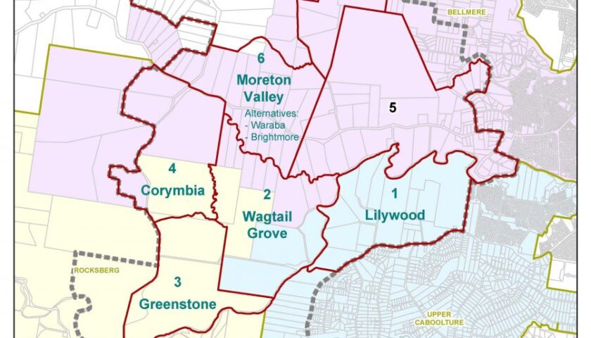
Planning for Waraba is guided by an Interim Land Use Plan, with an emphasis on sustainability, transport connectivity, and community liveability. The area includes five new suburbs: Waraba, Lilywood, Greenstone, Corymbia, and Wagtail Grove. The name Waraba, meaning “burn” in the Kabi Kabi language, recognises the area’s traditional land management practices and cultural heritage.
As with any large-scale development, challenges remain, particularly around infrastructure costs and housing affordability. Some developers have expressed concern over rising delivery expenses, prompting calls for greater investment and support to maintain momentum. However, the vision for Waraba remains strong: a master-planned city that balances growth with green space, liveability with opportunity.
Waraba will feature schools, town centres, public transport corridors, sporting fields, and extensive parkland. It’s being designed to be more than just a place to live—it’s a place to thrive. With careful planning and community input, Waraba is on track to become one of Moreton Bay’s most important and liveable future communities.
What Waraba Offers
-
Scale & Growth – A future urban region comparable in size to Mackay, with 70,000 residents and a diverse housing mix that includes social and affordable homes.
-
Connectivity – Well-planned roads, bike paths, public transport corridors, and employment centres designed to support sustainable living and economic opportunity.
-
Green & Community Spaces – Significant protected green areas, riverfront parklands, schools, sporting fields, neighbourhood centres, and other civic amenities to support liveability.
-
A City Designed Together – The design and planning of Waraba are grounded in community consultation, Traditional Custodians’ naming, and integrated planning tools focused on long-term resilience and equity.
Waraba PDA
https://www.moretonbay.qld.gov.au/Services/Building-Development/Planning-Schemes/Waraba-PDA
MBRC Planning Scheme – Caboolture West local plan
MBRC Planning Scheme – Caboolture West local plan
Caboolture West local plan code
https://consult.moretonbay.qld.gov.au/kse/event/4744/section/s1384469089572#s1384469089572